What we do
Have a look through some of our drone possibilities!
Inspection / Videography

Videography and Photogrammetry
Our Drone videography and photogrammetry services can create high-resolution videos which are easy to share or upload. As well as interactive maps of almost any sized area, from a private vineyard to an entire section of Native coastline. This allows ASM to provide detailed reports and beautiful visual aids that are easy to read and understand and share

Solar / Elevated Inspection
Drones can be used to monitor changes your worksite over time by reaching hard to view areas or comparing differences in regularly scheduled inspection photo and video data. We can also provide full-HD photography of any asset such as Solar Paneling and roof tiling.

Private/ Real Estate enquires.
With a dedication to functionality and a curiosity for what’s ahead of the curve, we keep our work practical, relevant and innovative. Please reach out with any questions or enquiries. We are always on the lookout for new and exciting possibilities and use of our services.

Commerical

Site Maps and Models
Drones can be used for construction site maps throughout the building cycle. ASM can help in the planning phases, providing detailed elevation models of the project site. They can help in site inspections and progress reporting during construction as well as up to date and easy to reference progression videos and aids

Industrial Asset and Equipment Maintenance
Drone inspections can be used for industrial projects and tower inspection where vision may be inaccessible due to height. Drones are the perfect solution for inspecting tall or inaccessible assets such as communication towers and cell towers. With drones, you can inspect these structures quickly and safely – with minimal disruption to your operations and avoiding problems that occur from external factors such as environmental or other hazards.
Environmental

Land Planning and Environmental Assessment
Our Drones can also be used for environmental site assessments. The use of drones in environmental site assessments can help to identify potential environmental shifts or hazards and provide detailed information about the site. All data GIS exportable and can be used for cm accurate 2D measurements, distances, areas and some volumetric calculations.

Golf Course and Parklands
Our precision orthomosaic maps and models in 2D and 3D can be used to rapidly capture aerial images of Golf courses, local council parks and ovals. The images are then processed using photogrammetry software to create a detailed map of the area. Each point contains X/Y axis and color information. This orthomosaic has uniform scale and can be used for cm accurate 2D measurements, distances, and areas.
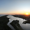
Costal Mapping and Modeling
2D and 3D aerial maps can be used to assist environmental management of coastal areas by providing detailed information about the area. The maps can be used to monitor changes in the environment over time by comparing differences in the maps
Couldnt Find What You Were Looking For?
Why Not Reach Out?
With a dedication to functionality and a curiosity for what’s ahead of the curve, we keep our work practical, relevant and innovative. Please reach out with any questions or enquiries. We are always on the lookout for new and exciting possibilities and use of our services.